In this article
- Anindya World View is my attempt to bring much of that publicly available information into one visual environment.
- From God's Eye View to Anindya World View
- How It Has Been Implemented on AnindyaNandi.com
- Starting Anindya World View for the First Time
- Searching Anywhere in the World
- Live Aircraft and Airspace Context
- Ships and Maritime Activity
- Roads, Places and Ground Context
- Weather Around the Selected Region
- Earthquakes and Environmental Events
- Active Fires and Thermal Anomalies
- Regional Information and Source-Backed Events
- Live Radio From Around the World
- Public CCTV Where Sources Are Available
- Drawing Directly on the World
- Different Ways of Seeing the Same World
- Meet Arka Inside World View
- A World View Built From Layers
- How I Recommend Exploring It
- What World View Should Not Be Used For
- Why the Project Matters to Me
- An Evolving Platform
- What can publicly available information tell us about this part of the world right now?
The internet gives us an extraordinary amount of information about what is happening around the world. The problem is that the information remains scattered. Aircraft are shown on one website, ships on another, earthquakes somewhere else, weather on another platform, satellite fire detections in a different system, radio stations in yet another directory, and maps form an entirely separate layer. Even when all this information is publicly available, understanding how different events relate to a particular place often requires moving between several websites and mentally joining the pieces together.
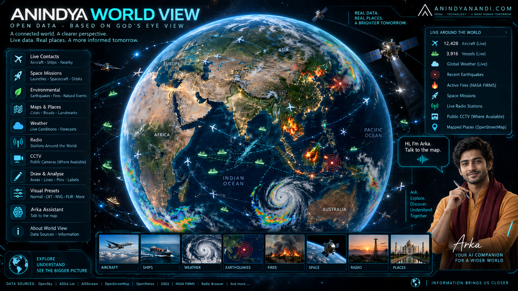
Anindya World View is my attempt to bring much of that publicly available information into one visual environment.
It is now integrated into AnindyaNandi.com as an interactive global
information interface built around a three-dimensional Earth. Instead of
beginning with a conventional search box or a list of news reports, you begin
with the planet itself. You can move across the globe, search for a place,
examine activity around it, switch data layers, inspect aircraft or vessels,
look at environmental events, explore space activity, listen to radio stations
and, where supported, use Arka to interact with the system through voice.
The public gateway is available here:
Anindya World View: ¹
https://anindyanandi.com/world/
The underlying standalone World View application can also be opened
directly here:
Direct World View: ²
https://eye.anindyanandi.com/
Why I Built Anindya World View
Most websites present the world as text. A headline tells us that an
earthquake has occurred somewhere. A weather report tells us that a storm is
developing somewhere else. A flight-tracking service shows aircraft. A marine
service shows ships. A map shows roads and places. Each is useful
independently, but the geographical relationship between them is often missing.
Anindya World View reverses that approach.
The location comes first. Information is then placed around that
location.
Suppose you are looking at the Arabian Sea. Instead of treating the sea
merely as a blue area on a map, World View can potentially give you maritime
contacts, nearby aircraft, mapped locations, weather conditions and other
available contextual information from connected public sources. Move towards
Japan and environmental events such as earthquakes become geographically
meaningful. Move towards a major airport and aircraft movement becomes part of
the landscape. Move towards a region affected by wildfires and
satellite-detected thermal activity can be understood spatially.
The objective is not simply to display more data. It is to make
different kinds of data geographically understandable.
From God's Eye View to Anindya World View
The underlying project began as what was internally called God's
Eye View, an experimental concept for placing multiple real-world data
feeds around an interactive Earth.
For its implementation on my website, it has been developed into a
distinct public identity:
ANINDYA WORLD VIEW
with the description:
OPEN DATA · BASED ON GOD'S EYE VIEW
The distinction is important. Despite the appearance of an intelligence
or surveillance interface, Anindya World View is not claiming access to
classified intelligence, restricted government systems, private surveillance
networks or secret tracking infrastructure.
It works by bringing together publicly available, openly accessible
or properly connected data sources and presenting their information
geographically. The live interface itself identifies data sources including
OpenSky, ADSB.lol, AISStream, OpenStreetMap and Open-Meteo, while its
environmental mode includes earthquake and fire information associated with
USGS and NASA sources.¹
That distinction between intelligence and information is fundamental to
the project. A surprising amount of what happens around the planet can already
be observed through legitimate public data. The challenge is organising it.
How It Has Been Implemented on AnindyaNandi.com
Anindya World View operates as its own application on the dedicated eye.anindyanandi.com
subdomain. The main AnindyaNandi.com website then provides a permanent World
View gateway at /world/.
This architecture allows the World View application to remain
technically independent while still functioning as part of the main website.
Visitors entering through AnindyaNandi.com receive the full-screen World View
experience without having to navigate through a conventional article layout,
sidebar or menu-heavy page.
A prominent AnindyaNandi.com control remains available within
the World View interface so that a visitor can return to the main site. The
control has deliberately been designed in the cyan visual language of the World
View rather than appearing as an unrelated website button.
The interface itself uses a cockpit-inspired design. Panels sit around
the central visual field while the globe remains the primary object.
Information appears contextually depending on what is selected, which layers
are active and where the user is looking.
Starting Anindya World View for the First Time
When a visitor first opens World View, the system provides four primary
ways to begin:
- Live Contacts:
Begin by looking at aircraft, vessels and nearby mapped intelligence.
- Space Missions:
Explore launches, spacecraft and orbital context.
- Environmental:
Look at live or recent earthquakes and active fire information.
- Explore Manually:
Start with the globe itself and decide independently what to examine.
There is also an option to prevent the first-launch screen from
appearing again.
This makes World View usable at two different levels. Someone who
simply wants to explore can begin with the globe, while a visitor looking for a
particular type of information can move directly into that context. The current
application describes these choices directly on its first-launch interface and
identifies Arka Voice as another way of interacting with the map.
Searching Anywhere in the World
One of the simplest ways to use World View is through the location
search.
Enter a city, landmark or other searchable geographical location and
the globe can be repositioned towards it. Once there, the location becomes the
centre around which other information can be explored.
This is where World View begins to differ from a normal globe.
You are not merely travelling virtually from Kolkata to London, Tokyo,
New York or Cape Town. Once you reach a location, you can begin asking a
different question:
What is happening around here?
That can lead into aircraft, ships, weather, environmental data, nearby
mapped sites, regional information and other enabled layers.
Live Aircraft and Airspace Context
Aircraft are among the most visually interesting elements of World
View.
The system uses publicly available aviation tracking information,
including OpenSky-related flight data and an ADS-B source layer. OpenSky
describes its API as providing live airspace information derived from aircraft
state vectors, while ADSB.lol provides extensive aircraft position, speed,
altitude, track and related ADS-B information.³ ⁴
When the relevant data is available, World View can present aircraft
geographically and provide contextual parameters such as:
- Ground speed
- Altitude
- Heading or course
- Position
- Nearby contacts
- Available route
context
- Movement relative to
the selected area
A contact does not have to remain just an icon floating over the globe.
It can become the focus of the interface.
Entering the Cockpit
One of the more experimental parts of Anindya World View is the cockpit
view.
When supported by available aircraft information, the visual
perspective can shift from watching an aircraft externally to a course-aligned
first-person representation. The interface includes aircraft-style information
such as altitude, ground speed, directional information and optical-plane
elements.
This is a visualisation of available tracking data rather than an
actual feed from an aircraft cockpit.
That difference matters.
World View is reconstructing the geographical situation from available
data. It is not connecting to an aircraft's internal navigation system or
camera.
The result nevertheless changes the way aircraft tracking feels.
Instead of looking at a dot travelling across a conventional two-dimensional
map, you can begin to perceive direction, terrain, surrounding geography and
nearby activity from a much more immersive perspective.
Ships and Maritime Activity
The same geographical approach extends to maritime traffic.
World View identifies AISStream as a maritime data source. AIS,
or Automatic Identification System, is widely used for broadcasting vessel
identity, position, course, speed and other navigational information. AISStream
provides real-time maritime events through its AIS data infrastructure.⁵
Where information is available, vessels can therefore be treated as
geographical contacts in much the same way as aircraft.
This becomes particularly interesting around major ports, shipping
lanes, coastal regions, canals and strategic maritime passages. A visitor can
visually understand that the ocean is not empty space. It contains moving
networks of commercial shipping, maritime routes and other observed activity.
As with aircraft tracking, coverage should never be interpreted as
complete. A vessel absent from a public AIS feed cannot automatically be
assumed to be absent from the sea.
Roads, Places and Ground Context
Moving objects only become useful when they can be understood relative
to places.
World View therefore uses mapped geographical context, including
OpenStreetMap information. OpenStreetMap is an openly licensed world map
created through collaborative mapping.⁶
This ground layer helps relate aircraft, vessels and events to actual
geography such as cities, roads, coastlines, landmarks and mapped sites.
The World View is therefore not simply a collection of tracking
markers. The underlying geography is an essential part of understanding why a
marker matters.
Weather Around the Selected Region
Weather is integrated into the contextual view through Open-Meteo.
Depending on location and data availability, the interface can present
information such as temperature, wind, sky conditions and precipitation.
Open-Meteo combines weather models from a number of meteorological
organisations and provides current and forecast weather information through its
API.⁷
This becomes particularly useful when weather is viewed beside another
layer.
An aircraft movement makes more sense when one can also understand the
weather around it. Maritime activity is easier to contextualise alongside wind
and weather. A wildfire becomes more meaningful when environmental conditions
can be considered around the same geography.
World View is designed around precisely this type of layered
observation.
Earthquakes and Environmental Events
Selecting Environmental from the opening screen gives another
way of looking at the planet.
Earthquake information can be associated with data made available by
the United States Geological Survey, which publishes real-time earthquake feeds
and web services.⁸
Instead of reading that an earthquake occurred at a latitude and
longitude, users can see the event in geographical relation to countries,
coastlines, populated regions and other activity.
That spatial context can often explain more than coordinates alone.
Active Fires and Thermal Anomalies
The environmental system also incorporates active-fire information from
NASA FIRMS, the Fire Information for Resource Management System.
NASA FIRMS distributes satellite-detected active fire and thermal
anomaly data using observations from instruments including MODIS and VIIRS.
NASA describes much of its global active fire information as near-real-time
data.⁹
These detections are valuable, but they need to be interpreted
carefully. A satellite thermal anomaly is not automatically proof that every
part of the marked area is burning. NASA itself notes limitations involving
resolution, cloud cover and the interpretation of thermal anomalies.
World View therefore treats these feeds as observed environmental
information, not as an emergency-service replacement.
Space Missions and Orbital Context
World View is not limited to activity on the Earth's surface.
The Space Missions context provides a separate way to inspect
launches, spacecraft and orbital activity. The interface maintains a
mission-oriented environment in which available missions can be selected and
explored relative to the globe.
This begins to connect terrestrial geography with activity above the
planet.
Launch locations, trajectories, orbital objects and mission information
are naturally geographical. A three-dimensional globe is therefore a
particularly suitable environment in which to understand them.
Regional Information and Source-Backed Events
Another contextual component is regional information.
As the World View resolves the area being observed, the interface can
acquire region-related information and present source-backed events. The system
explicitly distinguishes this from synthetic news generation with the interface
label SOURCE-BACKED EVENTS · NO SYNTHETIC NEWS.¹
The purpose is not to allow an AI system to invent an explanation for
whatever appears on the globe. Where event information is presented, the aim is
to connect the geographical view with source-based external information.
This distinction becomes increasingly important as AI-generated
interfaces become more common. A visualisation should help a user investigate
reality, not quietly manufacture it.
Live Radio From Around the World
World View also contains a radio layer.
When enabled, radio stations can be explored geographically, selected
and played through the interface. The radio directory is associated with Radio
Browser, an internet radio station directory.¹⁰
The interface includes station selection, tuning controls, previous and
next station controls, playback and volume adjustment.
This creates a completely different kind of geographical experience.
You may visually explore a country and then listen to a radio station
broadcasting from that region. Geography, live data and human culture begin to
occupy the same interface.
The application also clearly informs visitors that when a station is
played, the audio connects to the broadcaster and the broadcaster can
consequently see the listener's IP address.¹
Public CCTV Where Sources Are Available
World View contains a CCTV framework, but this requires an important
clarification.
The existence of a CCTV control does not mean that World View
has access to private cameras.
The system is intended to work only with camera information that is
publicly accessible or legitimately provided through connected sources. Where
supported camera sources exist, controls can include functions such as
selecting the nearest available camera, moving between cameras, focusing on a
camera position, visualising coverage, projection and calibration.
There is also provision for scene summaries, allowing
camera-linked information to be placed into the wider geographical context when
such data is available.
If no source exists for the selected area, there is simply no camera
information to show.
That principle applies throughout Anindya World View: absence of
data is not replaced with invented data.
Drawing Directly on the World
World View also includes analytical drawing tools.
A user can create:
- Areas
- Lines
- Pins
- Optional labels
This might appear like a small feature, but it changes the globe from
something that can merely be observed into something that can also be examined.
An area can mark a region of interest. A line can visually connect two
places or represent a route. A pin can mark a particular observation.
It is a simple analytical layer placed directly over the geographical
environment.
Different Ways of Seeing the Same World
The application includes several visual presets.
At present, these include:
- Normal
- CRT
- NVG
- FLIR
- Anime
- Noir
- Snow
There are also controls for elements such as HUD display, detection
density, 3D models, visual scope, bloom, sharpening and cleaner viewing modes.¹
Some of these are functional viewing modes, and others are primarily
visual treatments. Their purpose is to allow the same geographical environment
to be examined in very different ways without changing the underlying world
being observed.
For a user who simply wants information, Normal mode is the natural
starting point. For someone interested in the visual experience of the
interface, the alternative styles turn World View into something much more
experimental.
Meet Arka Inside World View
Arka, the AI assistant associated with AnindyaNandi.com, has also been
integrated into the World View environment.
Instead of treating artificial intelligence as a separate chat window
disconnected from the globe, the longer-term idea is for Arka to function as an
intelligent interface between the visitor and the geographical system.
The World View first-launch screen already tells visitors:
**“ARKA VOICE lets you talk to the map.”**¹
Arka appears inside the interface through an animated avatar and voice
interaction layer. When voice functionality is used, the interface can indicate
listening and speaking states. The current voice implementation uses the Cedar
voice.
The purpose of this integration is straightforward. Complex
geographical interfaces can contain many controls. Voice interaction can
gradually make some of those functions more natural.
Instead of thinking only in terms of buttons, layers and menus, the
direction is towards interaction such as asking the system to locate something,
explain what is being displayed or move towards a particular context.
Arka is therefore not intended merely as decoration beside the globe.
It is being developed as part of the interface itself.
A World View Built From Layers
The best way to understand Anindya World View is to think of it not as
a single map but as a collection of layers around one geographical frame.
At different times, that frame can contain:
- The Earth and
terrain
- Cities, roads and
mapped sites
- Aircraft
- Maritime vessels
- Weather
- Earthquakes
- Active fires and
thermal anomalies
- Space missions and
orbital context
- Regional events
- Public radio
stations
- Supported
public-camera context
- User-created areas,
lines and markers
- AI-assisted
interaction through Arka
Not every layer will contain information everywhere and not every
provider has uniform global coverage.
That is not a flaw that should be concealed. It is an unavoidable
characteristic of real-world open data.
Related reading: Pakistan's Rapid Satellite Expansion: A New Strategic Challenge for India ?
How I Recommend Exploring It
For someone visiting Anindya World View for the first time, there is no
need to activate everything simultaneously.
A better approach is to begin with one question.
For example:
“What aircraft are around this region?”
Open Live Contacts, move towards the area and inspect available
aircraft.
Then try:
“What is happening environmentally around this part of the world?”
Switch towards environmental information and examine earthquake or fire
activity.
Or start with:
“What does maritime traffic around this coastline look like?”
Move towards the coast and examine available vessel contacts.
After becoming comfortable with the globe, experiment with space
missions, radio, alternative visual styles, drawing tools and the cockpit
interface.
Finally, try Arka Voice.
The system becomes much easier to understand once one stops thinking of
it as a conventional webpage and starts treating it as an instrument panel
for exploring the world.
What World View Should Not Be Used For
The visual appearance of World View can make public data look
extraordinarily powerful. That makes limitations especially important.
Anindya World View should not be treated as:
- An
air-traffic-control system
- A military
intelligence system
- A maritime
navigation system
- An emergency warning
service
- An authoritative
disaster-response platform
- A substitute for
official aviation or marine notices
- Evidence that an
aircraft, ship, fire or event does not exist simply because it is not
displayed
Open-source feeds can be delayed, incomplete, unavailable, filtered or
limited by reception coverage. Aircraft may not transmit information visible to
a particular network. Ships may disappear from AIS coverage. Satellite fire
detection has physical and observational limitations. Weather models remain
models rather than perfect descriptions of atmospheric conditions.
World View visualises available observations. It does not claim
omniscience.
Why the Project Matters to Me
The most interesting thing about Anindya World View is not the fact
that an aircraft moves across a 3D globe or that an earthquake marker can
appear on a map.
It is the possibility of bringing different fragments of reality
together.
Modern information is often abundant but disconnected. We know more
about the world than at any earlier point in history, yet much of that
knowledge arrives in separate feeds, separate applications and separate
formats.
Geography gives those fragments a common language.
An aircraft has a position. A ship has a position. An earthquake has a
position. A fire has a position. A city has a position. A weather system
affects an area. A radio station originates somewhere. A space launch begins
somewhere on Earth before moving beyond it.
Once these things are placed together, relationships become easier to
see.
That is the central idea behind Anindya World View.
An Evolving Platform
The present implementation is not intended to be the final form of the
project.
Anindya World View has been designed as an evolving platform.
Additional public data sources, better contextual interpretation, improved Arka
interaction, richer event intelligence and deeper relationships between
different layers can be added without changing the fundamental concept.
The globe remains the foundation.
Everything else becomes another way of asking a simple question:
What can publicly available information tell us about this part of the world right now?
For readers of AnindyaNandi.com, researchers, travellers, map
enthusiasts, aviation followers, maritime observers, technology enthusiasts or
simply anyone curious about the planet, Anindya World View offers a different
way to explore that question.
Not through a list.
Not through a feed.
But by looking at the world itself.
References
¹ Anindya
World View, Live Application
Anindya World View
https://eye.anindyanandi.com/
² Anindya
World View, AnindyaNandi.com Gateway
AnindyaNandi.com
https://anindyanandi.com/world/
³ The
OpenSky Network API Documentation
The OpenSky Network
https://openskynetwork.github.io/opensky-api/
⁴ ADSB.lol
Public ADS-B aircraft tracking and data
https://adsb.lol/
⁵ AISStream
Real-time maritime AIS data
https://aisstream.io/
⁶
OpenStreetMap
Open geographical mapping data
https://www.openstreetmap.org/
⁷ Open-Meteo
Weather API and meteorological data
https://open-meteo.com/
⁸ United
States Geological Survey, Earthquake Feeds and Web Services
USGS Earthquake Hazards Program
https://earthquake.usgs.gov/earthquakes/feed/
⁹ NASA
FIRMS, Fire Information for Resource Management System
NASA Land, Atmosphere Near real-time Capability for Earth Observations
https://firms.modaps.eosdis.nasa.gov/
¹⁰ Radio
Browser
Community-driven internet radio directory
https://www.radio-browser.info/
Ask Arka about what you just read
Ask for a summary, clarification, the evidence behind an argument, or more writing by Anindya on the same subject.

Discussion